Simulating Cod Management Alternatives
Investigating a mismatch.
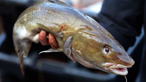
Atlantic cod in U.S. waters are managed as two distinct stocks. Recently, however, an interdisciplinary review revealed that the current stock boundaries do not align with the spatial structure of biological cod populations. In principle, resolving this discrepancy could facilitate both fishery and conservation objectives. Therefore, to inform the management decision making process we are using simulation testing to evaluate the performance of several alternative spatial management scenarios.
Project Goals:
- Develop a population dynamics model that captures the newly understood biological population structure of Atlantic cod.
- Work with stakeholders and managers to develop a plausible suite of alternative spatial management scenarios that better align with biological populations of cod.
- Support the management decision making process by evaluating the performance of spatial management scenarios that vary in their degree of alignment with cod populations.
The Challenge
Currently, Atlantic cod in U.S. waters are assessed and managed in two spatial units. Recently, however, an interdisciplinary review of cod stock identity information revealed that these units do not align with the spatial structure of biological cod populations. Specifically, the best available science suggests that there are five distinct populations in U.S. waters, with at least one that spans the current boundary between stock units. In instances like this, where management does not match the scale of fish biology, achieving sustainable fisheries management can be difficult. Resolving the issues can sometimes help accomplish both fishery and conservation objectives.
To reconcile this newly realized misalignment, the Atlantic Cod Research Track Working Group (ACRTWG) is implementing four spatial assessment units instead of two. For a variety of practical and economic considerations, however, management bodies may wish to move forward with management units that differ from these assessment units and do not fully reflect the spatial complexity found in biological populations. Therefore, to support the decision-making process, we are using simulation testing called Management Strategy Evaluation (MSE) to quantify the relative performance of alternative spatial management unit structures. We will test four candidate structures identified through stakeholder engagement workshops that considered ecological, practical, and economic implications. They range in complexity as well as their alignment with the revised assessment units and biological population structure.
What is MSE?
MSE is a tool that can examine and compare the expected outcomes of candidate management approaches relative to biological and economic objectives. Briefly, it projects a stock forward in time by applying fishing pressure within a population dynamics model. At set intervals, this model is used to simulate data that is analogous to the input data underlying empirical stock assessment. These simulated data are fed into assessment and management procedures that emulate the real-world management process and return catch advice. This catch advice then informs the fishing pressure that is applied within the population dynamics model. In this way MSE emulates real-world fisheries management by allowing the status of the simulated population to inform the fishing pressure that is applied moving forward.
Our Approach
For this project we are developing a MSE framework that reflects the recently understood biological population structure of cod. Specifically, we simultaneously model five biological populations, each with distinct and realistic population dynamics (e.g. spawning region, spawning season, recruitment dynamics, growth rates). As a part of this, we will model climate impacts on population dynamics, such as recruitment or natural mortality, when appropriate. Although spawning for each population is limited to its home range, the populations can mix through larval dispersal and seasonal movement of adults.
Every two years we spatially aggregate the data from these five populations according to the four spatial assessment units defined by the ACRTWG. We use this aggregated data to generate stock assessment inputs that have the same characteristics of real-world survey and catch data and inform four independent stock assessments. The details of each assessment will emulate decisions made by the working group. For example, if the ACRTWG determines that the assessment for a particular stock-unit requires a data-limited approach, or should incorporate climate information in the assessment, we will implement those decisions within our framework. The stock status estimates from these assessments are then used to calculate catch advice through management procedures that closely mimic real-world processes. This catch advice is applied in the biological population dynamics models during subsequent time-steps.
These aspects of the simulation will remain fixed across our experimental design. That is, all simulations will have the same biological population structure, assessment unit structure, and assessment specifications. These are constrained by recent findings on cod population structure and decisions of the ACTRWG. Instead, we will vary the spatial management unit boundaries and compare the performance of candidate management unit structures with respect to both fishery and conservation objectives.
Project Team
-
![This is the staff photo for lisa kerr]()
-
![The staff photo of Roger Brothers]()
-
![The staff photo of Jerelle Jesse]()
-
![This is a portrait of a man smiling.]()
Steven Cadrin, Ph.D.
Professor
University of Dartmouth
-
![This is a photo of a man.]()
Yong Chen, Ph.D.
Professor
Stony Brook University
-
![NOAA logo]()
Charles Perretti, Ph.D.
Research Fishery Biologist
Northeast Fisheries Science Center
Project Sponsors
Read More
-
![Climate change hurting N.E. cod population, study says - The Boston Globe]()
Climate change hurting N.E. cod population, study says - The Boston Globe
Press Clips
-
![2021 Research Progress Update]()
2021 Research Progress Update
Our research team has been hard at work over the last year. To keep you updated on their progress, we've developed a report showcasing some …
Announcements
-
![Industry Collaboration Fuels New Fishing Technology]()
Industry Collaboration Fuels New Fishing Technology
As fisheries and regulations have changed, Captain Jim Ford is one of many fishermen finding ways to adapt. Ford is a long-term collaborator and partner …
Perspectives
-
![Improving Climate-Readiness of US Fisheries]()
Improving Climate-Readiness of US Fisheries
The National Oceanic and Atmospheric Administration (NOAA) has awarded the Gulf of Maine Research Institute $1.1 million to investigate impacts of climate change on groundfish. …
Announcements