Gulf of Maine Temperature Report: Summer 2026
Reports | Oct 26, 2026
Over the past decade, our scientists have led a body of research that highlights temperatures in the Gulf of Maine. To keep you informed, we share seasonal and annual updates about conditions in our region.
Read on for an inside look at what we've learned in our summer 2026 Gulf of Maine temperature report.
Overview
This report provides a seasonal update on sea surface temperature (SST), bottom temperature (BT), and vertical thermal structure across the Gulf of Maine (GoM) during summer 2026 (June 1 – August 31). Building on the 2025 Gulf of Maine Temperature Report, this update examines summer temperature conditions, long-term warming trends, historical rankings, daily and monthly variability, marine heatwaves and cold spells, and seasonal thermal stratification using NOAA Optimum Interpolation Sea Surface Temperature (OISST) observations and the Glorys12v1 global ocean reanalysis.
Consistent with the 2025 annual report, temperature conditions are assessed across the GoM Ecological Production Unit (EPU), providing a consistent regional framework for tracking changes at the surface, near the seafloor, and throughout the water column. By examining both surface and subsurface conditions, this report offers a more complete picture of ocean temperature variability and its potential implications for the GoM marine ecosystem.
Key Takeaways
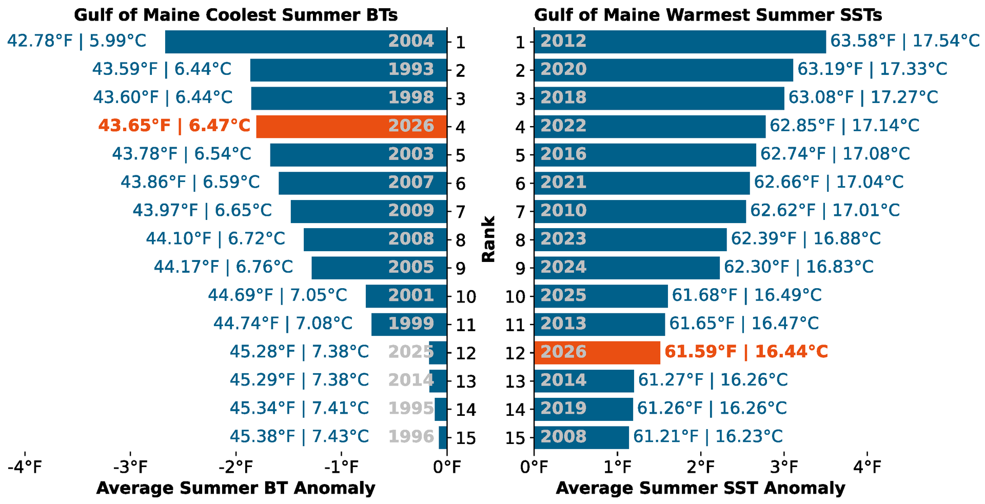
- Summer 2026 was relatively warm at the surface but exceptionally cool at the bottom. Summer SST averaged 61.59°F (16.44°C), ranking as the 12th warmest summer since 1982, while bottom temperature averaged 43.65°F (6.47°C), ranking as the fourth coolest summer since 1993 and the coolest since 2004.
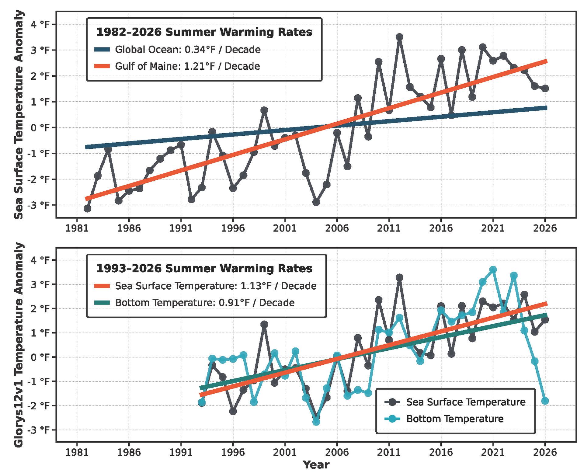
- Long-term summer warming continues across the GoM despite unusually cool bottom conditions in 2026. Based on NOAA OISST, summer SST has warmed at a rate of 1.21°F per decade since 1982, more than three times the global ocean average (0.34°F per decade). Over the 1993 – 2026 period, GLORYS12v1 indicates warming trends of 1.13°F per decade at the surface and 0.91°F per decade at the bottom.
- Surface and bottom waters experienced contrasting temperature extremes throughout the summer. Two short-lived surface marine heatwaves (11 and seven days) contrasted with a prolonged 77-day bottom marine cold spell extending from late spring into summer, highlighting persistent subsurface cooling.
- Summer 2026 exhibited an unusually large surface-to-bottom temperature difference. The regional mean SST–BT difference remained above its climatological average throughout summer, reaching approximately 25°F in August, while mixed-layer depth remained near its typical summer value of approximately 10 m.
- Contrasting surface and subsurface temperatures highlight the importance of monitoring the full water column. These conditions provide important environmental context for understanding changes in marine habitats, vertical mixing, and the availability of suitable thermal conditions for marine organisms across the GoM.
Summer temperature conditions
Summer sea surface temperatures (SSTs) in the Gulf of Maine (GoM) have continued to exhibit a pronounced long-term warming trend (Figure 1). Based on the NOAA OISST record (1982 – 2026), summer SSTs have warmed at a rate of 1.21°F per decade, more than three times the global ocean average (0.34°F per decade). The GLORYS12v1 reanalysis also captures this long-term warming trend, with summer SSTs increasing at a rate of 1.13°F per decade over the 1993 – 2026 period (Figure 1, bottom panel), slightly lower than the rate calculated from the OISST dataset over the same period (1.41°F per decade). Differences between the two estimates may reflect variations in spatial resolution, data assimilation methods, and the representation of regional ocean conditions.
Although summer 2026 SSTs remained warmer than those observed during much of the 1980s, 1990s, and early 2000s, they were relatively cool compared with the exceptionally warm summers of the early 2020s.
Summer bottom temperatures (BTs) in the GoM have also exhibited a strong long-term warming trend, increasing at a rate of 0.91°F per decade since 1993, based on the GLORYS12v1 reanalysis (Figure 1, bottom panel). However, following exceptionally warm bottom conditions in the early 2020s, summer BTs declined progressively from 2023 through 2026, reaching approximately 1.80°F below the climatological average and representing the coolest summer bottom conditions since 2004. This sustained multi-year cooling contrasts with the persistent long-term warming trend. In 2026, summer SSTs remained above their long-term average, highlighting a pronounced divergence between surface and bottom temperature conditions.
How did summer 2026 compare to historical record?
To place summer 2026 into historical context, Figure 2 ranks the warmest summer SST and coolest BT years in GoM based on seasonal averages. Summer 2026 recorded an average SST of 61.59°F (16.44°C), ranking as the 12th warmest summer since 1982. Although cooler than the exceptionally warm summers of the early 2020s, summer 2026 remained among the warmer summers on record, consistent with the region's long-term warming trend.
In contrast, bottom temperatures were unusually cold. Summer 2026 recorded an average BT of 43.65°F (6.47°C), ranking as the fourth coolest summer since 1993. Only 2004, 1993, and 1998 experienced cooler summer bottom conditions, making 2026 the coolest summer at the seafloor since 2004.
Spatial patterns of summer 2026 temperature anomalies and long-term trends
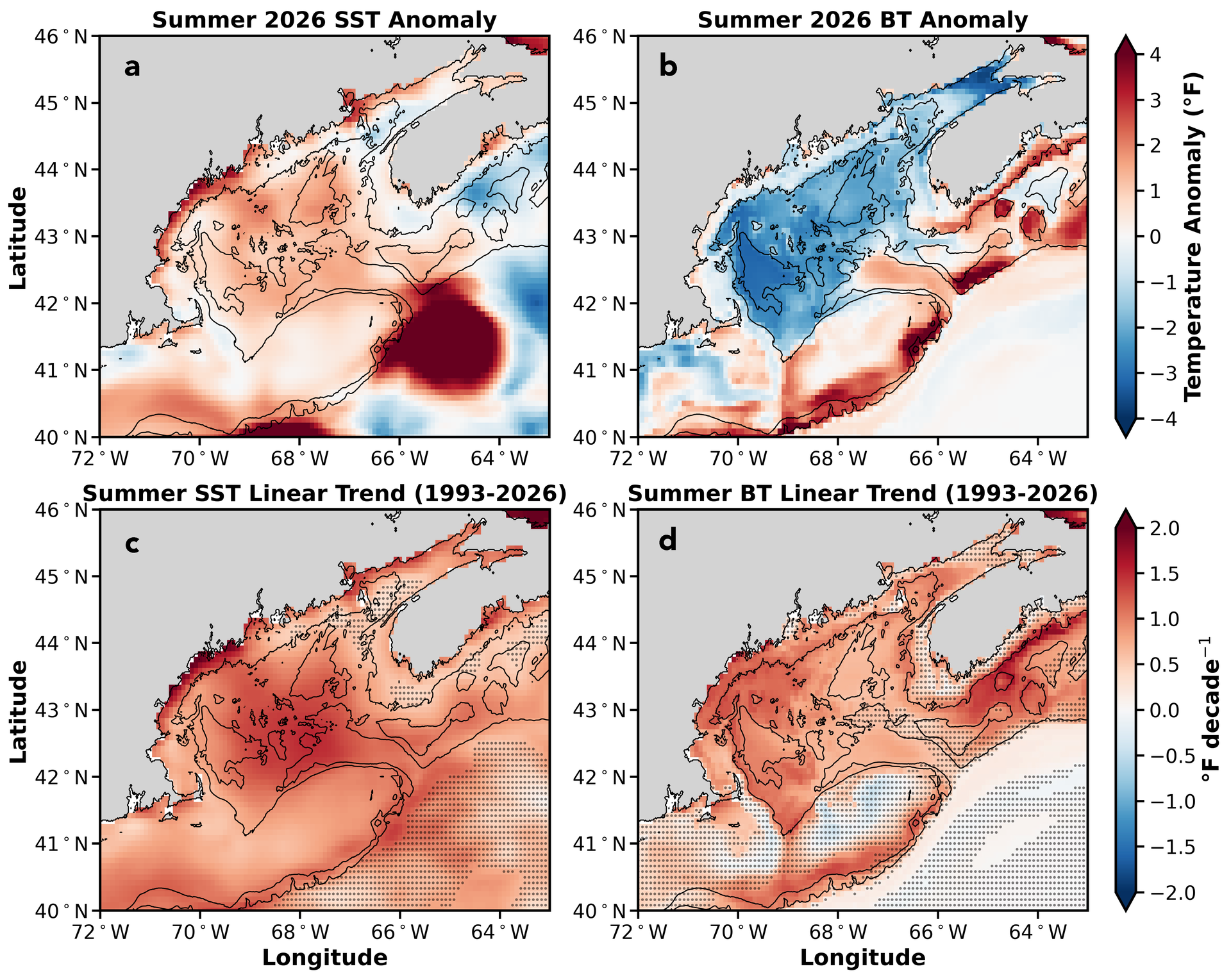
Summer 2026 exhibited pronounced spatial differences in SST and BT anomalies across the GoM (Figure 3). SSTs were generally above the 1993 – 2020 climatological mean across much of the western and central GoM, with particularly strong positive anomalies along portions of the Maine coast and in the southwestern Gulf. Outside the GoM, a pronounced warm SST anomaly was observed near the entrance to the Northeast Channel. Further examination of GLORYS12v1 surface temperature, sea surface height, and velocity fields revealed this strong positive temperature anomalies is consistent with a coherent warm-core ring existing during June and July. In contrast, cooler-than-average surface temperatures were observed in parts of the eastern GoM and offshore waters, highlighting substantial regional variability in summer surface conditions.
Bottom temperature anomalies displayed a markedly different spatial pattern from those at the surface. Widespread negative BT anomalies occurred across the western and central GoM, with the strongest cooling concentrated over the shallow Bay of Fundy and intermediate-depth central Gulf regions. In contrast, positive BT anomalies were present along portions of the outer shelf and shelf break, particularly toward the eastern and southern boundaries of the Gulf. These warmer bottom conditions may be partly influenced by the nearby Gulf Stream warm-core ring observed during June and July, although further analysis is needed to determine its role in transporting warm water toward the GoM.
Despite the contrasting temperature anomalies observed in summer 2026, long-term warming trends remain evident across much of the GoM (Figure 3c-d). Summer SSTs have increased throughout most of the region since 1993, with relatively strong warming across the western and central Gulf and along coastal areas. Summer bottom temperatures have also increased across much of the Gulf, with particularly strong warming over portions of the western shelf and northeastern GoM. However, BT trends exhibit greater spatial variability, with weaker or statistically insignificant trends across parts of the outer shelf regions.
Daily temperature variability and cold spells in summer 2026
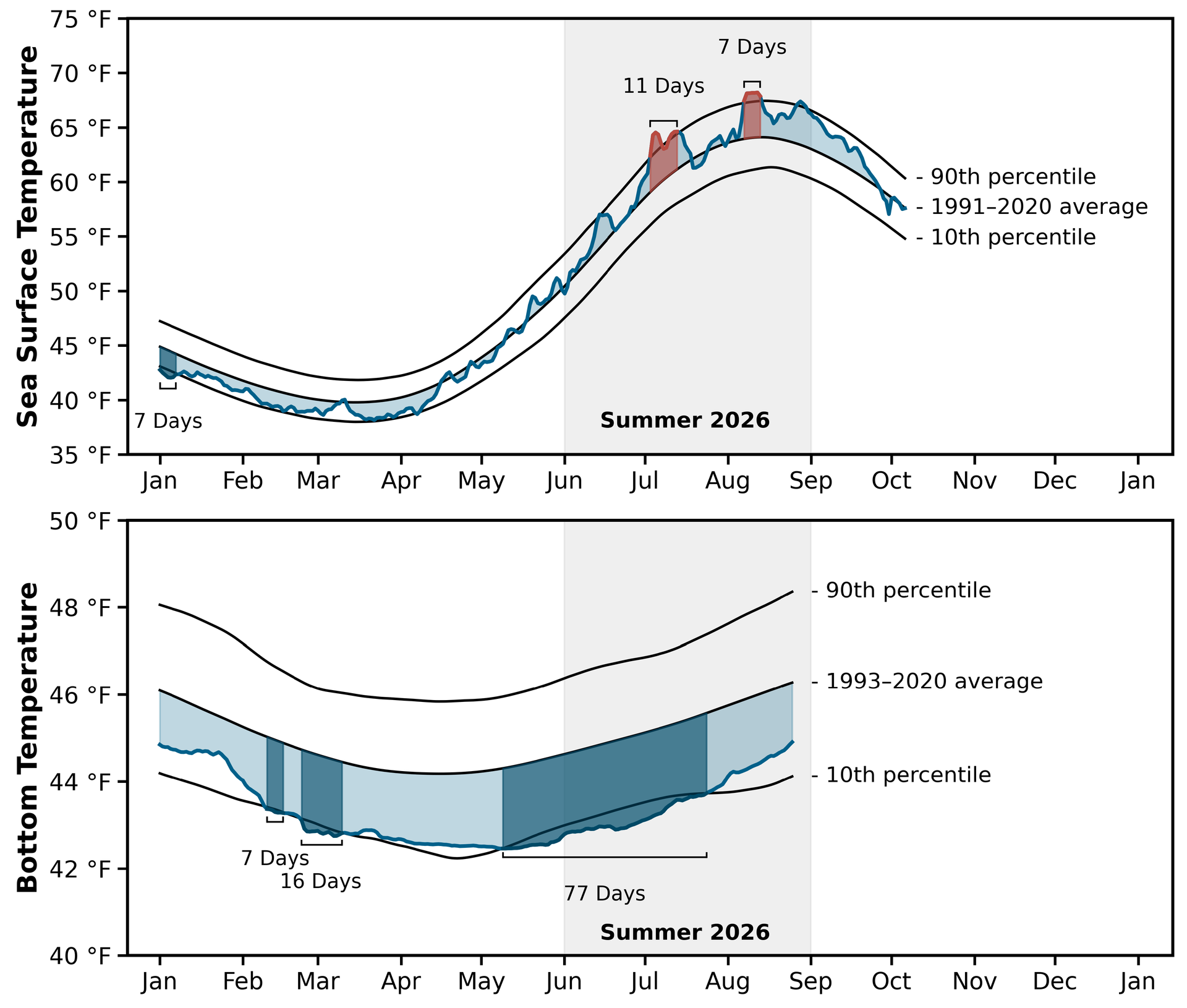
Daily SST and BT time series provide additional context for the seasonal evolution of summer 2026 temperature conditions in the GoM (Figure 4). Surface temperatures generally remained above the long-term mean throughout much of the summer. Two marine heatwave events occurred during July 3 – 13 and August 7 – 13, lasting 11 and seven days, respectively. Outside these relatively short-lived extremely warm events, summer surface temperatures remained largely below the 90th percentile threshold and almost above the long-term mean, indicating that summer 2026 was characterized by relatively warm with episodic surface extremely warming, contradictory to cooler surface conditions in Jan – March, suggesting much larger seasonal amplitude in surface temperature variation.
Bottom temperatures followed a markedly different seasonal path. BTs stayed below the climatological mean all summer, including a 77-day marine cold spell from May 9 through July 24, during which temperatures fell mostly below the 10th percentile threshold. This persistent cold at depth is consistent with the widespread negative BT anomalies in Figure 3 and the historically cool summer bottom temperatures in Figures 1 and 2.
Unlike the exceptionally warm summers of the early 2020s, which saw frequent and long-lasting surface marine heatwaves, summer 2026 had only two short-lived events of 11 and 7 days. Bottom conditions shifted even more sharply, from predominantly warm in recent years to exceptionally cold in 2026. A more comprehensive assessment of historical marine heatwave and cold-spell variability will be presented in the 2026 annual Gulf of Maine Temperature Report.
The contrasting evolution of SST and BT highlights a pronounced vertical difference in temperature conditions during summer 2026. While surface waters experienced intermittent marine heatwaves, bottom waters remained persistently cooler than average, including an exceptionally long cold spell. These contrasting conditions underscore the importance of monitoring both surface and bottom temperatures to capture the full extent of thermal variability and its potential implications for marine ecosystems in the Gulf of Maine.
Summer thermal stratification status
Thermal stratification in the GoM typically strengthens during spring and summer as surface waters warm and become increasingly separated from the cooler waters below. This seasonal development influences vertical mixing, nutrient transport, and marine habitat conditions throughout the region. The evolution of thermal stratification through summer 2026 is illustrated using the surface-to-bottom temperature difference (SST–BT), mixed-layer depth (MLD), and the vertical distribution of temperature anomalies (Figure 5).
Following the early development of thermal stratification during spring, the surface-to-bottom temperature difference continued to increase rapidly through summer 2026 (Figure 5a). SST–BT remained above the 1993 – 2020 climatological mean throughout the summer, approaching or exceeding the 90th percentile during portions of July and August. By August, the regional mean SST–BT difference reached approximately 25°F, indicating a substantially larger temperature contrast between surface and bottom waters than typically observed during this season.
The evolution of MLD provides a complementary perspective on summer stratification (Figure 5b). Following a rapid shoaling during spring, the regional mean mixed layer remained shallow throughout summer 2026, generally near 10 m, comparable to its climatological seasonal cycle during the summer. Together, the elevated SST–BT difference and shallow MLD reflect the persistence of a strongly thermally stratified water column during summer 2026.
The vertical distribution of temperature anomalies provides additional insight into these contrasting surface and bottom conditions (Figure 5c). Positive temperature anomalies were largely confined to the upper-50 m water column during summer, with particularly warm conditions developing near the surface in July and August. In contrast, negative temperature anomalies persisted below approximately 100 m, with pronounced cooling extending through the deeper layers of the GoM. Several prolonged cold-spell events were identified at intermediate and deeper levels, particularly below approximately 150 m, while marine heatwave conditions occurred intermittently near the surface. This pronounced vertical separation of warm and cold anomalies highlights the uneven thermal conditions throughout the water column and suggests that unusually cool subsurface waters contributed to the enhanced surface-to-bottom temperature gradient observed during summer 2026.
Together, these observations indicate that summer 2026 was characterized by strong thermal stratification, with relatively warm surface waters overlying an unusually cold subsurface environment. Although this report does not directly investigate the processes responsible for these conditions, the persistence of cold anomalies at depth underscores the importance of subsurface ocean variability in shaping the seasonal thermal structure of the GoM. Such changes in vertical temperature gradients may influence mixing, nutrient exchange, and the distribution of suitable thermal habitats for marine organisms.

Monthly progression in summer surface and bottom temperature anomalies
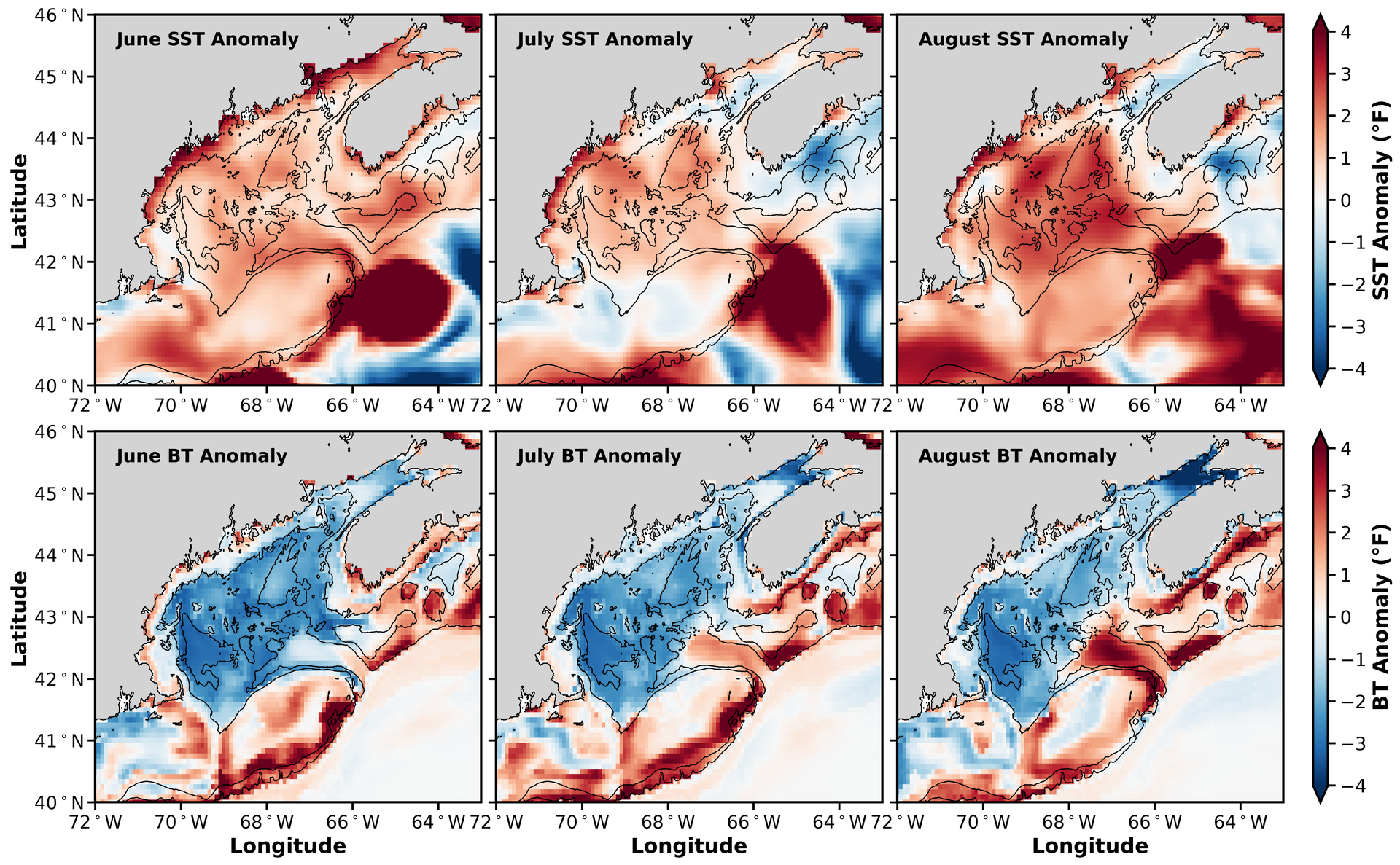
Monthly temperature anomaly maps reveal the evolution of summer 2026 conditions across the GoM (Figure 6). In June, positive SST anomalies were widespread across the western and central Gulf, with particularly strong warming along portions of the Maine coast and in offshore waters south of the Gulf. During July, warmer-than-average surface conditions persisted across the western Gulf, while cooler SST anomalies became more apparent in portions of the eastern Gulf and adjacent offshore waters. By August, positive SST anomalies intensified and expanded across much of the central and western Gulf, although cooler-than-average conditions remained in parts of the eastern Gulf. These changes highlight substantial month-to-month variability in surface temperature conditions during summer 2026.
BT anomalies exhibited a markedly different spatial pattern from those at the surface. Negative BT anomalies remained widespread across the western and central Gulf throughout June, July, and August, with particularly strong cooling over the Gulf interior. In contrast, positive BT anomalies persisted along the Northeast Channel connected to adjacent slope waters and upstream coastal Scotian Shelf inflows, both showing enhanced warming throughout the summer months. Unlike SST, which showed substantial spatial and temporal variability throughout the summer, the broad pattern of anomalously cool bottom waters remained relatively consistent across all three months.
Overall, summer 2026 was characterized by a persistent contrast between relatively warm surface waters and unusually cold bottom waters across much of the Gulf. While surface warming intensified across the western and central Gulf toward late summer, bottom temperatures remained well below their climatological averages across much of the Gulf interior. This contrast is consistent with the enhanced surface-to-bottom temperature differences and persistent subsurface cooling shown in Figure 5, highlighting the uneven vertical structure of ocean temperature conditions during summer 2026.
Data sources, methods, and reproductivity
This report integrates satellite observations and global ocean reanalysis products to characterize summer SST, BT, MLD, and thermal stratification variability in the GoM. All analyses presented in this report are fully reproducible using publicly available datasets and transparent methods described below.
Data Sources
NOAA OISST v2 (Optimum Interpolation Sea Surface Temperature)
We use the NOAA OISST v2 daily dataset (0.25° spatial resolution), available from 1982 to present, to calculate sea surface temperature (SST) anomalies, long-term trends, seasonal cycles, and marine heatwave and cold spell statistics. OISST provides a consistent multi-decadal record suitable for long-term trend analysis and allows direct comparison with prior GMRI warming reports.
GLORYS12v1 Ocean Reanalysis
To improve spatial detail and extend the analysis to subsurface conditions, we use the GLORYS12v1 global ocean reanalysis (1/12° horizontal resolution, 50 vertical levels) from 1993 onward (the satellite altimetry era). GLORYS12v1 assimilates satellite and in situ observations into a dynamical ocean model, providing three-dimensional temperature fields. Except surface and bottom temperatures, density-defined MLD was also obtained from this reanalysis for summer thermal stratification analysis.
Climatology and Baseline Periods
Temperature anomalies are calculated relative to fixed baseline climatologies: 1991-2020 for NOAA OISST (to maintain consistency with previous GMRI warming reports and other NOAA climate assessments); 1993 – 2020 for GLORYS12v1 (to ensure internal consistency within the altimetry-era reanalysis record). Daily climatologies were constructed using a smoothed seasonal cycle derived from multi-year daily means, ensuring comparability with marine heatwave detection thresholds.
Marine Heatwave and Cold Spell Definition
Marine heatwave and cold spell events were identified following the framework of Hobday et al. (2016) and Oliver et al. (2018). Events were defined as periods during which daily SST: exceeded the smoothed 90th percentile (MHW) or fell below the smoothed 10th percentile (cold spell), for at least five consecutive days. Gaps of up to two days below (or above) the threshold were merged into a single event. Event characteristics, including start date, end date, duration, and peak intensity, were derived directly from the daily SST time series. Bottom temperature events were evaluated using the same percentile-based framework, applied to GLORYS-derived bottom temperature time series.
Regional Delineation
The GoM domain used in this report is identical to that adopted in the 2025 Gulf of Maine Temperature Report. All analyses are based on the GoM Ecological Production Unit (EPU), replacing the rectangular study domain used in earlier GMRI warming reports. Using a consistent EPU-based domain ensures direct comparability with the 2025 annual report while providing a geographically and ecologically representative definition of the GoM.
Reproducibility
All datasets used in this report are publicly available. Analyses were conducted using standard statistical methods for anomaly calculation, linear trend estimation, percentile threshold detection, and spatial averaging. The use of fixed climatological baselines ensures consistency across figures and comparability with prior GMRI warming assessments.
Recommended Citation
If you would like to cite this report, please use:
Gulf of Maine Research Institute. 2026. Gulf of Maine Warming Update: Summer 2026 https://gmri.org/stories/gulf-of-maine-warming-update-summer-2026
Author Contributions
The report was led and written by Dr. Zhuomin (Jasmine) Chen.
Acknowledgements
The author thanks Dr. Janet Duffy-Anderson for her thoughtful review and constructive comments on the draft report.